Some of you may recall from last year that Thanksgiving is not celebrated on Thanksgiving day here in McMurdo, but is instead celebrated on the Saturday following Thanksgiving. Work weeks here are 6 days long (Monday through Saturday) with Sunday as the one day of the week designated as a "weekend". While it may sound terrible, it's really not that bad and no one seems to mind working the extra day. To avoid interrupting the work week, major holidays are always celebrated on Saturdays so people can enjoy a 2-day weekend.
As part of the Thanksgiving holiday, there is always a 5k Turkey Trot race that begins at 10am Saturday morning. The Turkey Trot starts in McMurdo and goes about halfway to Scott Base (the New Zealand base on the other side of the hill) and back again. The Turkey Trot is always "something not to miss" and usually looks like Halloween crashed Thanksgiving's party. Many of the participants dress in some sort of costume to run the race and this year was no exception. The race always begins in front of, and ends at the chapel.
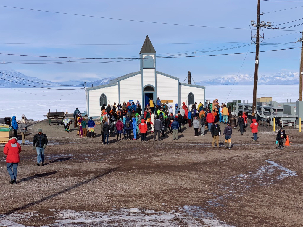 |
| Getting ready for the 5k Turkey Trot. |
There was a cold wind blowing this day, but that didn't dampen any spirits and as 10am drew near, everyone began to line up.
 |
| Getting ready to start the race! |
And then they were off!
 |
| The start of the race .... (for the record, the wind was at their backs and they weren't leaning into it; no one was dressed up to be The Weather Channel guy in a hurricane) |
The serious runners quickly took off and set the pace, leaving opportunities to photograph some of the other participants.
 |
| More costumed runners |
Then came some of the more unique costumes ...
 |
A blue bear, Batwoman, and a pickle (dead center) all competed in the 5k
|
 |
| Even a banana ran in the race |
 |
| A Tyrannosaurus Rex also made an appearance | |
And probably one of the most unique costumes was the guy who tied a rope around his waist and connected it to a wooden palette he was dragging behind him as he ran. It can be hard enough to just walk around the area with the rocks in the roads and the uneven icy patches, let alone run and drag a palette behind you so Palette Man is now my new favorite superhero!
 |
| A man and his palette |
You'll notice in the last picture the guy on the far left who was photographing Palette Man. He is a photographer with the Wall Street Journal (and also happens to be my roommate). They ran a special article in the Wall Street Journal complete with video. If you'd like to see it, check it out at the
Wall Street Journal.
As the last of the runners passed, I quickly walked over near the Crary Lab where everyone was looping back up the road.
 |
| More awesome costumes |
 |
| Hi, Sylvester!!! |
 |
| A tiger, a dancer and another shot of the pickle |
After the race, it was time to begin preparations for Thanksgiving dinner. There were roughly 900 people on station and there were five different dinner times throughout the day to ensure everyone would have time to make it to one. Like last year, the galley staff did an absolutely phenomenal job with dinner. They also took some time to decorate the galley for the occasion.
 |
| The galley |
The day, however, didn't end there for me. We had the latest dinner time (7pm, at our own choosing) and a pressure ridge tour was being offered that evening at 10pm. I managed to catch the sign up sheet not long after they put it up and snagged a slot (only 10 were available). These tours are always extremely popular and it can be hard to secure a spot. I was particularly interested in this one because the sun (while still up) would be lower in the sky, leading to less harsh glare on the ice.
What are pressure ridges? These ridges occur when the ice shelf pushes the sea ice against the shore so intensely, that the ice first forms ridges and valleys about 6-10 feet tall. As the pressure increases, the ridges can oftentimes buckle and break under the pressure resulting in large chunks of ice being pushed upwards. What's the difference between the ice shelf and the sea ice? (You ask a lot of good questions!) The ice shelf is essentially a floating glacier and is constantly moving at roughly 2 meters (~6 feet) a day. It can be 300 feet thick or more in places and does not melt each year. All of our sites are installed on the ice shelf and all the aircraft (including the C-17) land on the skiways located on the ice shelf. The fact that the ice shelf is moving can make for some interesting times at the beginning of each season. We have the GPS coordinates from where our sites were last year and we have to account for movement of the ice shelf to guess where they have moved to before we fly out to them. One of our pilots this year nearly flew past Lorne because he was using old coordinates from last year that had it over a mile and half from where it actually was.
Unlike the ice shelf, the sea ice usually breaks up every summer and then refreezes every fall and winter. It is much thinner and is maybe 10-15 feet thick. There is a very distinct visual line between the two where the thicker ice shelf is usually a little higher than the thinner sea ice.
Seals tend to hang out near the pressure ridges because they can usually find easy access to the ocean water below. That also means the pressure ridges can be dangerous if you aren't careful. Each year, the Kiwi's send out their mountaineers to flag a safe path for people to walk along so you can observe the pressure ridges up close and (mostly) safely. Our guide this year told us that she had a gentlemen last year who stepped through the ice and sunk in up to his thigh. After telling us that, she also informed us she was carrying a flotation device attached to a rope that could be tossed to a person if one of us fell through the ice into the water so everyone else could pull the person back out. That sold it for me, I was definitely ready to get on with the tour!
 |
| The pressure ridges begin as rounded ridges with valleys in between - Mt Terror can be seen in the distance (and is not a pressure ridge) |
 |
| A closer view of the some of the thicker ice that had been thrust upwards - the icicles were a result of some of the warmer temperatures recently | | | | | | | | | | | | | |
Last year, the route that was flagged was mostly parallel to the
pressure ridges ... this year the mountaineers got adventurous and the
route took us
through the pressure ridges.
 |
| Our fearless leader explaining how we were all going to walk through
the breaks in the ice while we all stood a safe distance away waiting
for her to go first .... |
After I crossed through the gap, I took a close up picture of the ice.
 |
| Closeup view of the ice |
 |
| More breaks in the ice - Mt Erebus can be seen in the background with a small plume of steam rising from the lava lake at the summit |
 |
| Ice "sculptures" with a melt pool in the the foreground |
 |
| Catchin' a wave in Antarctica |
 |
| Castlerock as viewed from the pressure ridges |
As I mentioned earlier, the pressure ridges are a great place to view the seals. It was getting too late in the season to see many of the pups, but there were still a few sleepy seals laying on the ice for us to photograph.
 |
| Weddell seals snoozin' on the ice - their coloring and spots are unique to each |
 |
| Another snoozin' seal .... unless they are searching for food, this is about all they ever do - the seal also looks about how I felt after Thanksgiving dinner |
By the time we got back from the pressure ridge tour, it was about 12:30am. Since the next day was Sunday, most people were out at the bars or other various parties so I decided to tackle Hut Point Loop Trail, especially since there was almost no wind. I expected the loop to be, well, shorter than it was and maybe just do a little climbing (emphasis on the "little"). I started down the path about 1am and finally reached the peak about an hour and 15 minutes later. The views from the top were amazing and what I didn't expect to see (though thinking about it afterwards I probably should have expected it) was the open ocean on the other side of Ross Island. Not only that, but there were large icebergs floating in the ocean.
 |
| The edge of the sea ice can be seen (lighter color at bottom) next to the open ocean (darker color across the middle) with some icebergs in the open waters |
I also noticed another iceberg that had frozen into the sea ice last season.
 |
| An iceberg frozen into the sea ice - a glacier can be seen slowly winding down out of the mountains in the background |
I finally finished my day at 3am when I walked back into McMurdo. I'm hoping to do one more hike on this trail again before I leave to see how much more of the sea ice has broken up (and if there are more icebergs). More to come!


Wow . . . I'm beginning to think I need to go to Antarctica.
ReplyDelete